1 Introduction
What are protective forests? What types of forests are considered in this textbook? Why are protective forests necessary and what future challenges will they have to face? This chapter provides insights and definitions - acting as background information for the whole textbook.
1.1 Protective Forests in the European Alpine Space Region
Protective forests are considered as a defining element of the alpine landscape – offering natural protection against natural hazards. Such forests, represent an essential factor in the risk reduction of natural hazard processes over long periods of time on large potential natural hazard disposition areas. For thousands of years, mountain forests have been subject to a variety of demands and uses (forest pasture, litter use, snowfall, temporary arable farming, intensive use of wood for mining, etc.), which became particularly intense at the end of the Middle Ages. It was not until the end of the 18th century that French scientists recognized intensive use and clearing in the mountains as the cause of major floods “in the lowlands”. This knowledge was soon generalized and applied to the entire Alpine region.
## Lade nötiges Paket: leafletFigure 1.1: Map of dominant leaf type (coniferous/broadleave) tree distribution in Europe 2015
Since the 19th century, European countries in Alpine regions are historically leader in managing protective forests. Those ecosystems and management techniques can be seen as part of European natural and technical heritage. This is because mountain forests are a major factor in reducing risk on people, infrastructure and resources from natural hazards including floods, debris floods, debris flows, snow avalanches and rockfalls. In Austria as well as South-Tyrol (Italy) about 30\(\%\), in Switzerland about 40\(\%\) (Duc and Brändli 2010) and in Bavaria even 60\(\%\) (Binder, Macher, and Müller 2019) of the forested area is designated to forests for which the prevention of gravity-driven natural hazards is the major control function.
1.2 Protective forests in Austria
Austria is covered by more than four million hectares of forest, which can be divided into 22 (9 principal) ecoregions with special regard to the regional climate and to the woodland communities that prevail due to these climatic conditions. Within these ecoregions seven altitudinal zones are distinguished from phytocoenological and climatical points of view.
Today, about 30\(\%\) of the forest area in Austria is assigned a protective function to avoid serious natural hazards, and according to the interim evaluation of the Austrian Forest Inventory, this share is increasing (Gschwantner et al. 2019). Main tree species are spruce [Picea abies] (52\(\%\)), larch [Larix decidua] (17\(\%\)),beech [Fagus sylvatica] (13\(\%\)), swiss stone pine [Pinus cembra] (7\(\%\)) and other coniferous respectively decidual trees (6\(\%\)).
In protective forests, indirect and direct protection can be distinguished (Motta and Haudemand 2000). Indirect protection refers to the general role of forests in reducing soil erosion or improving watershed condition and air quality (“Standortsschutzwald” according to the Austrian Forest Act (1975)). Direct protection forests specifically protect people or infrastructures like buildings or utility corridors (“Objektschutzwald” according to the Austrian Forest Act).
Figure 1.2: Protective forest map
Closed forests (enclosure protective forests) are meant to protect humans, human settlements, facilities or resources. (§27 Forest Act (1975)) [“Bannwald”].
Figure 1.3: Map of closed forests in Austria
1.3 Challenges
Inventory data show that only half of such classified protective forests in Austria have a stable structure. The reasons are often identified as significant aging, a lack of tree species diversity or a lack of regeneration in areas in need of rejuvenation - causes which, in addition to excessive game pressure, are also due to changes in climate. Climate change leads to higher stress factors and thus inevitably to adaptations of forest ecosystems.
Since the end of the 19th century, the air temperature in Austria and the Alpine region has risen by almost 2°C and a further temperature increase of + 1.3°C is expected, independent of the emission scenario, by 2050. If the Paris Agreement is fulfilled (RCP 2.6), a long-term increase of just under 2°C is expected. In case of non-compliance (RCP 8.5) even up to plus 4°C. However, it can already be said that more than half of global warming since 1950 has been caused by humans and continues to increase.
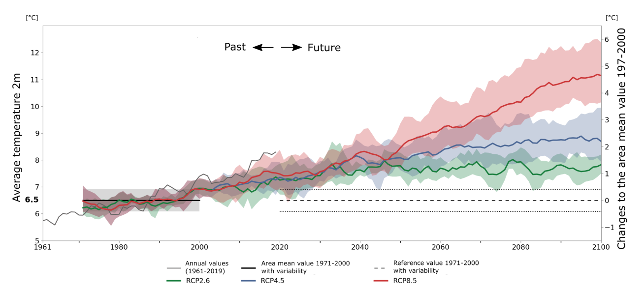
Figure 1.4: Climate scenarios in the Alps. Adapted after Olefs et al. (2021)
With the expected increase of the global average surface temperature, the spatial and temporal impact of climate change on forests:
- suggests an increase in evaporation and therefore more frequent and intense drought events.
- suggests a decrease in snow depths and snow cover duration (\(10-40\%\) drastic measures; \(50-90\%\) no measures) by the end of the 21st century.
- leads in the long term to a higher liquid fraction of precipitation (more rain instead of snowfall) and to a faster melting of existing snowpacks – superimposed by strong year-to-year and multidecadal natural climate variations.
- has resulted in an increase in mean precipitation intensities since the 1960s while the total number of precipitation days has remained constant. Long-term trends to be assumed are weakly significant positive (i.e. increasing) precipitation on the northern side of the Alps and slightly negative on the southern side of the Alps. However, these long-term trends are exceeded by the expected year-to-year variations!
This concerns in particular climate-related forest disturbances such as forest fires, wind and insect outbreaks, which will likely increase in the coming decades. Here, climate change can alter the frequency, intensity, duration and timing of such natural disturbances (Dale, Hemstrom, and Franklin 1986). Sebald et al. (2019) mapped time series of annual forest cover from 1986 to 2016 with a resolution of 30m (Landsat, Level 1) with more than 10,000 torrential catchments in Austria. They analyzed the effect of topography, geomorphology, forest and (forest) disturbances on occurrence and frequency of documented flood and debris-flow events 1 over a 30 year period. Their study is one of the first quantitative indications that natural disturbances increased the probability of torrential events showing that forest cover and patch density have the strongest negative effect on occurrence and frequency of torrential hazards. Thus, in addition to forest cover, it seems to matter how the forest area is distributed in the watershed. Figure (1.5) shows the same forest area distributed differently, with a more favorable picture in the right - in terms of occurrence and frequency of torrential processes.
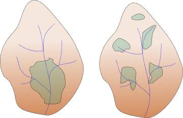
Figure 1.5: Differences in “patch” densities
However, they also found that disturbances had a positive effect on the occurrence of debris flows with increasing extent but showed no effect on the occurrence of flooding. For the type of disturbance, one can distinguish between disturbances that happening in a short period of time (called pulse disturbance) and disturbances being distributed regularly over the period investigation (so called press disturbances). Sebald et al. (2019) showed that press disturbances can rather be regarded as drivers for torrential processes.
Scheidl et al. (2020) found that climate change might likely increase runoff and erosion disposition in steep forested headwater catchments. However, they also found that climate induced natural disturbances can reduce the risk from landslides in such catchments, with the positive effect of accelerated tree species change and increasing root cohesion outweighing a potential negative effect of disturbances on the water cycle.
Thus, future challenges for sustainable natural hazard management in protection forests will continue to intensify. To name an example, this applies specifically to the management of high-elevation afforestation, which is directly intended to supplement or even replace technical mitigation structures against natural hazards or to reduce heavy runoff events. From more than 3,200 afforestation sites (established between 1906 and 2017), these days about 520 sites are older than 40 years, covering 3,800 ha (more than 1/3 of total area afforested until 2017) (Scheidl et al. 2021). Such high-elevation afforestation sites, which have passed from an early stage to a so-called young stage, require now silvicultural management strategies that consider future effects of a changing climate in order to maintain the protective effect at an acceptable level. Although guidelines such as ISDW (Perzl 2008) or NaiS (Frehner, Wasser, and Schwitter 2005) offer targeted silvicultural interventions to improve or maintain protective effects of forests, the question remains how natural hazard management can be adapted to counteract the effects of climate change in Austria’s protective forests. While the efficacy of protective forests could be substantially reduced by climate change, Scheidl et al. (2020) stated that such systems also have a strong inherent ability to adapt to changing conditions. The priority objective must therefore be to strengthen the fields of action and research in accordance with the existing natural and biogenic resources to ensure the protective effect of forests against natural hazard processes. However, this first requires the creation of an empirical basis on which the current state of knowledge can be adapted to climate change to ensure a sustainable natural hazard management.
References
All events caused damages and have been documented in the Austrian torrential event catalogue (Heiser, Hübl, and Scheidl 2019)↩︎